2025.12.31 Areas of Outer Western Mass.
This is one article in a series. Click for a table of contents of the full series. The table will be updated with links as the articles are published.
Well, another year is down the hatch since my initial post about areas of Massachusetts. That means it’s time to hurriedly write and publish the first in my planned series of detailed posts about the areas in each region of the state. (As noted in the initial post, these regions generally don’t correspond directly with well-established regions, but rather are intended to contain a fairly consistent number of areas each.) We’ll go roughly from west to east through the regions, so we’ll start with Outer Western Mass. See below for a map of all the areas discussed, or see the initial post for the full zoomable map of the state with more layer choices. For simplicity of definition, I’m counting this region as including all the areas that overlap with Berkshire County. This then includes the Berkshire valley towns and cities as well as many of the hill towns between there and the Pioneer Valley. Let’s get right into it.
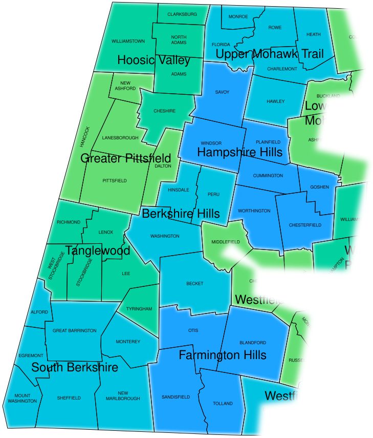
South Berkshire
Mt. Washington, Egremont, Alford, Great Barrington, Sheffield, New Marlborough, Monterey.
Basically the area focused around Great Barrington, with a lot of open area and settlement along the Housatonic River in Great Barrington and Sheffield, and also including the higher-elevation towns just to the east and west. Mt. Washington, at the southwestern corner of the state and this area, is very isolated from the other towns in the area, with only one road connecting it to another MA town (Egremont); but since it’s fully surrounded (within MA) by other South Berkshire towns that are more connected to each other, it goes in. To the east of this area are the more sparsely-settled towns of Farmington Hills; to the northeast, Monterey is barely connected to Tyringham. To the north, on the other hand, the adjacent Tanglewood towns are quite connected to Great Barrington, but it still seemed to make more sense to group them separately, as will be discussed further below.
Tanglewood
Tyringham, Lee, Lenox, Stockbridge, West Stockbridge, Richmond.
Includes the population core of the south-central Berkshires — Stockbridge, Lee, and Lenox — which is also lies in the Housatonic valley. Named of course for the Tanglewood music center, which straddles Stockbridge and Lenox and is thus centrally located within the area. Tyringham has less settlement, but its linear open valley is oriented toward Lee, whereas it has very little connection to its other neighbors.
Richmond and West Stockbridge, composing the western part of the Tanglewood area, present some difficulty that illustrates the tradeoffs made in devising these areas. They’re fairly connected to one another, but they’re separated from Lenox and Stockbridge by mountain ridges with not many roads traversing them. Whereas Richmond is fairly connected to Pittsfield, and West Stockbridge to Great Barrington! (As are Lenox and Stockbridge respectively. The village of Housatonic ties West Stockbridge, Stockbridge, and Great Barrington all together.) So there’s sort of two parallel and fairly separate bands of settlement between Pittsfield and Great Barrington. But I decided to stick with having Richmond and West Stockbridge within Tanglewood because their town centers are closer to Lenox and Stockbridge centers resp., via the main roads that do cross over the ridges, than to Pittsfield and Great Barrington centers resp. And that keeps the areas in question more compact in shape, and more even in land area and number of towns.
Greater Pittsfield
Pittsfield, Dalton, Lanesborough, New Ashford, Hancock.
This includes all the towns except for those in the Tanglewood area whose settlement is more connected to Pittsfield than to any other centers. Much of it is in the upper Housatonic River watershed. New Ashford is mostly within the Hoosic River watershed (don’t mind the confusingly similar river names), but its settlement seems a bit more oriented to the south. The Mt. Greylock massif largely separates much of this area from the Hoosic Valley.
Hancock, mountainous and narrow, and extending along one third of the western border of MA, is an odd case. It has two disconnected portions of road network separated from one another, the northern one connected to Williamstown, Lanesborough, and Stephentown NY, the southern to Pittsfield, Richmond, and New Lebanon NY. Since Lanesborough and Pittsfield are fairly connected to one another and thus make sense to have together in an area, it seems to make the most sense to include Hancock in Greater Pittsfield as well.
Hoosic Valley
Williamstown, Clarksburg, North Adams, Adams, Cheshire.
This northwesternmost area of the state comprises a fairly continuous web of settlement along and near the Hoosic River, as it winds around the Mt. Greylock massif through the northern Berkshires. Cheshire is pretty close to Lanesborough as well, but it seems a bit more connected to Adams. The Hoosac [sic] mountain range rises along the eastern edge of this area, separating the Hoosic Valley from the higher-elevation areas to the east.
Upper Mohawk Trail
Florida, Monroe, Rowe, Heath, Charlemont, Hawley.
The vertiginous rise of Route 2 from North Adams around the famous hairpin turn and up over a mountain pass, before entering the sparsely settled plateau of Florida, is a paradigmatic transition between areas. To be fair, this seems to be the case with most of the roads connecting Florida to other towns, e.g. Route 2 at the other end of town winding down the Cold River gorge toward Charlemont. So it kind of seems like Florida (maybe together with Monroe) should be an area unto itself. But I want to avoid one- or two-town areas as much as possible, and in terms of population density, it seems sensible to group all of these towns together.
Charlemont is the center of population and road connectivity here. It’s somewhat connected to the Lower Mohawk Trail towns, but its long stretch east-west between sparser towns to the north and south make it more logical to include as the center of Upper Mohawk Trail. Hawley has some connection to Plainfield and Ashfield (like Hancock, it has two disconnected road networks), but also to Charlemont; the Berkshire East Mountain Resort straddles the two towns. Charlemont and Heath have little connection to Colrain to the northeast.
Hampshire Hills
Goshen, Chesterfield, Worthington, Cummington, Plainfield, Windsor, Savoy.
[record scratch] Savoy?! Isn’t Savoy one of those mountainous Route 2 towns? Well, the northern part is. However, overall the town’s settlement seems more oriented to the south, via Routes 8 and 116, connecting Savoy to Windsor and Plainfield. Now, Windsor itself is a bit of a question; on driving through it on Route 9 recently, I perceived its settlement as more concentrated to the west, toward Dalton and ultimately Pittsfield, than to the east. However, overall it has more road connections to the east — and north to Savoy.
The rest of the area is pretty uncontroversial to group together: still pretty low-density (compared to the Pioneer Valley) but with more farmland and housing than the highest-elevation towns. Massachusetts: An Explorer’s Guide (see reference list in initial post) notes that “Hampshire Hills” is a tourism term applied to these towns in recent decades. I think it works nicely, as the towns besides Windsor and Savoy are all in Hampshire County. (Although web search results for the name mostly have to do with Hampshire Hills Athletic Club in Milford NH.)
Berkshire Hills
Peru, Hinsdale, Washington, Becket.
I note on reviewing Massachusetts’s school districts that there’s a Berkshire Hills school district consisting of Stockbridge, West Stockbridge, and Great Barrington — very much distinct from this area. However, I think the name still works here, because the Berkshire Hills more broadly refers to the entire hilly/mountainous area between the Berkshire valleys and the Pioneer Valley, and this area is near the center thereof (in fact, it’s contained within the Central Berkshire school district). This is a group of towns I’m not familiar with at all, but they have some continuity of settlement along and near Routes 8 and 143, seemingly more so than e.g. Hinsdale to nearby Dalton. They’re separated from the Housatonic valley by October Mountain and other hilly conserved land, and they also have little connection to the Westfield Hills and Hampshire Hills areas to the east. Becket has some connection to Otis to the south but also seems somewhat separated from it by the Mass Pike.
Farmington Hills
Blandford, Otis, Sandisfield, Tolland.
“You nincompoop!” I hear you shout. “You absolute idiot! Blandford is almost entirely in the Westfield River watershed, not the Farmington River watershed!!” Well, hear me out. That’s why I call this area Farmington Hills, denoting the hills whence the headwaters of the Farmington watershed, as well as those of adjacent watersheds, arise. It is so that Blandford is in the Gateway school district with the Westfield Hills towns, but its few road connections with those towns appear pretty transitional. Toward Otis and Tolland, on the other hand, there’s more continuous settlement and more open land, with population concentrated around Otis Reservoir, which contains the tripoint of those three towns. There’s some residential development straddling Otis and Sandisfield, which gives them more connectivity than either one has to the towns to the west. Sandisfield and Tolland, meanwhile, are tied together by the village of New Boston, which spans the Farmington River.
Granville makes some sense to group with the Farmington Hills towns in terms of elevation, land use, and population density, but its center of town is so far to the east that it seems more reasonable overall to include it in Westfield Valley.
That does it for the areas of Outer Western Mass. Next up (when? good question): Inner Western Mass.