Note: Please email me for permission if you want to reproduce any of the material in this report (jbdowse at gmail), and then please link to this page.
A Closer Look at Rural Swiss Building
Robert G. Wilmers Jr. 1990 Memorial Student Travel Abroad Fellowship Report
by Jonathan Dowse, August 2005
Switzerland is characterized by a high degree of diversity in a remarkably small area. Its topography is the essential reason for this: dominated by the Alps, the country comprises many regions separated from one another by mountains, and this separation has frequently prevented Switzerland's many facets from blending together. The diversity manifests itself in language, for one thing: Switzerland has four official languages, German, French, Italian, and Romansch. The high Alps in the southwest part of the country, near the Matterhorn, form the corner where the three major languages meet, while Romansch, a distinctive Romance language, is spoken by a small but dedicated population of speakers in certain valleys of the southeastern, alpine canton of Graubünden.
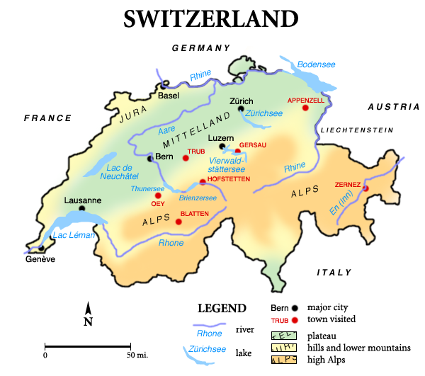
Another example of wide diversity within Switzerland is the architecture and construction methods of its rural areas. This was my particular area of interest in traveling through the country for six weeks at the beginning of this summer. Having visited rural Switzerland previously on vacation, I was a great fan of, in particular, the sturdy wooden buildings of the alpine canton Valais. The Valais contains the highest peaks in Switzerland, a number of them higher than 4000m above sea level, plus long valleys between the mountain ridges. One of those valleys, the Lötschental, is the place I know best in all of Switzerland and is where my fascination with Swiss architecture began. I returned there at the end of this trip, but first I visited six other areas, to try to get as well-rounded an impression of Swiss rural building as possible. The following map that I made shows the seven places I went to, along with major cities and natural features for orientation.

The first area I visited is in the alpine part of Canton Bern known as the Bernese Oberland. The Oberland consists of a complex series of high peaks and curved valleys, most of which drain to the north, into two narrow lakes lying end-to-end, the Brienzersee and the Thunersee (a.k.a. Lake of Brienz and Lake of Thun; see map). The well-known city Interlaken is located between these lakes, hence its name. The Aare River flows down from the mountains to the east, through the Brienzersee and the Thunersee, and then north into the flatter part of Canton Bern.
I stayed in the town of Hofstetten, just north of the Aare before it flows into the Brienzersee. My primary reason for staying there was because of the town's close proximity to the Ballenberg Open-Air Museum. Ballenberg contains a large number of rural buildings (over 100) that come from all over Switzerland — in each case the building was taken down from its original site, transported to Ballenberg, and rebuilt there. The museum is an amazing resource, and it was particularly useful to me, as I could gain a thorough overview of Swiss building right on the one campus. It was the only place where I was able to a large extent to go inside buildings; subsequently I had to content myself with observing them mostly from the outside. It took three days for me to see and photograph all the museum's buildings exhaustively (and exhaustingly). My knowledge of Swiss building styles and methods exploded in just those three days, assisted additionally by a great little guidebook to the museum which explained (in English) lots of things about its buildings that I would have missed otherwise.
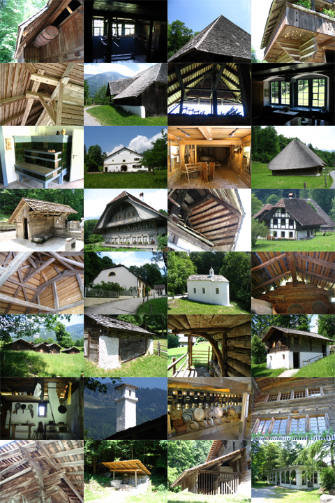
I ought to write much more about what I saw and learned at Ballenberg, but there's so much there that to do it justice would overwhelm the report. Instead, I made a collage of photos I took at Ballenberg (see below). In the collage, notice the great variety of building shapes and of construction details. Especially mind-boggling to me at the time were the often incredibly complex support structures built for barns and houses. These would become somewhat more commonplace, you'll see, once I got to know the Emmental region. With the time I had left in Hofstetten after the museum odyssey, I hiked around the surrounding area to get a feel for the local architecture, which I'll discuss in depth below. Daily long hikes around the settled countryside would be the pattern for the rest of my stay in Switzerland.

My digital camera, a Canon PowerShot A75, was my primary recording tool during the trip, thanks to the huge memory card I bought specifically for the project. I took over 4000 pictures in total (that's about 90 pictures a day; the 250-300 pictures per day at Ballenberg skewed the average somewhat), and those are only the pictures I saved. One unforeseen perk for me was that my photography skills improved considerably with all that practice, and I became acquainted with all sorts of useful features of the camera. Since photography turned out to be such an emphasis, the pictures I took will be an integral part of this report and will be referred to by number. An original goal of the project was to learn more about settlement patterns in addition to the construction of individual buildings, and this turned out to be difficult because of the lack of written resources on the subject. I will, however, bring up what I observed of settlement patterns. The project effectively became, instead, an in-depth comparative survey of architectural styles.
From this point I'll mention each of the places I visited, not in chronological order, but in a mostly geographical (and architecturally logical) sequence.


